 This Is Not A
BLOG!
Date: 16/06/10
On The Road Again
Let me tell you about yesterday.
The weather - and other circumstances - having conspired to prevent me from doing anything very much with my customary June fortnight away from the deepening shit-pit of work, I really needed to get out of the house for a bit. So, shortly after ten on Tuesday morning, I donned my boots and rucksack and set off.
Before we go any further, here's a map:
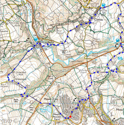
(Start from the red dot at bottom centre and go anti-clockwise. You'll need to throw a six to start)
I took the old, familiar route down through the village - past the school and the church - then turned right just beyond the Old Vicarage onto Glyon Lane. Walking down past the kennels, I came to an odd sight just before Yord Cottages. There was one of those new-style metal kissing-gates which had been installed at the end of the footpath which comes down from Halcog. Very good, except for one thing: there being no fence beside it, there was no need for anyone to use the gate anyway. Perhaps they're doing it by instalments.
I carried on past the cottages and past the end of the road I wanted to take. This rather wanton act was due to the fact that I wanted to see whether the buttress of an old railway bridge still stood a bit further down. Turning the corner by the old farm buildings, I could see that stand it still did:
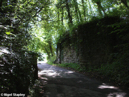
The bridge once carried a railway line which looped off the Wrexham-Birkenhead line at Tanyrallt on the other side of the ridge, ran around the end of Windy Hill and led to the mines in the Moss Valley. I had last seen this wall in June of 1978 when, having had an 'O'-level exam in the morning, me and the future folk singer of note Annette Batty had walked home this way.
Having thus reassured myself that not everything from my past gets routinely demolished, I doubled back to Yord Cottages and turned right up Cae Pen Tŷ Road.
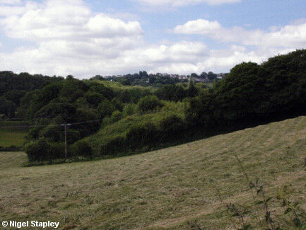
I stopped by The Windings - at one time a noted recording studio (Chumbawamba recorded part of their 1995 album Swingin' With Raymond there), but now seemingly a mere bed & breakfast place - and looked back up the hill. I could still see the end of my road:
Pressing on, I noticed - just as I had going down Glyon Lane earlier - that there was an awful lot of wild garlic growing at the side of the road. In fact, it was snitheing (as we say hereabouts) just about everywhere I went. It brought back another memory of my school days. Our school bus used to go along Minera Road (which runs parallel to the north of Cae Pen Tŷ Road). These were the days when coaches such as those supplied by W J Hanmer & Sons for our transport had opening windows and fanlights. From mid-May onwards - especially on warm days - the cry used to go up as we came up Minera Road from the Ffrwd: "Shut the windows!". This was because the wild garlic grew in profusion along the banks of the River Cegidog in Ffrwd Wood below, and the smell used to hit you like a club as you came up alongside it.
I dropped down Furnace Road into the small village of Ffrwd (The Ffrwd to us). As the name 'Furnace Road' would suggest, there was once industry here; ironworks, brickworks, and a quarry (which was the last industry to go, sometime in the 1980s). There was also once a plan to have a section of the Ellesmere Canal here, but work stopped after just two years at the tail end of the eighteenth century.
The village is odd in the sense that it straddles a county boundary. In the picture below, the houses on the left are in the County Borough of Wrexham, whereas the ones on the right are in Flintshire. The boundary runs down the middle of the road all the way from Pen Y Coed in the west to Ffrwd bridge (which is in the foreground of this shot), before following the line of the river further east:
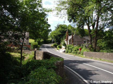
The boundary follows the demarcation between the old counties of Denbighshire and Flintshire. It used to be said that you could tell when you had crossed the line between them with your eyes shut, because the standard of road maintenance in Denbighshire was so bad.
I then started the long, slow slog up Barracks Lane towards Cymau. As I said, there used to be a quarry up here, but this has now been turned into a nature reserve. The wild garlic again grows in multitudes at the side of the road, due to poor drainage and heavy shade. Further up, though, and having had a brief conversation with a horse grazing in an adjacent paddock, I found vegetation which was far nicer looking (and smelling):

I knew that Barracks Lane would take me a fair way eastwards of Cymau itself, and that there was a footpath which operated as a short cut into the village, but I decided to stay with the road and turn left up the hill at the end of it. I reached the welcome refuge of the seat by The Olde Talbot Inn just on midday.
A ten minute break later, I set off with the intent of visiting Cymau's parish church. However, walking along the main road, I came to Bethesda chapel (1860) with its attendant graveyard. As I've remarked before, cemeteries are eminently readable, and I was unable to counter my curiosity. Strangely, very few of the graves seemed to date from the last ten years, which suggests that either no-one dies in Cymau anymore, or some bureaucracy has deemed that no-one is to be buried there now, or that no-one would be seen dead in the village (which I consider highly unlikely).
Morbid curiosity slightly sated, I walked further along and turned left by the Post Office; down the lane which leads ultimately to the ford at Lower Lodge, but which passes the gateway to All Saints Church. The gate itself was padlocked, as it has been every other time I've been past it, but a stone stile gives foot access to the track leading to it.
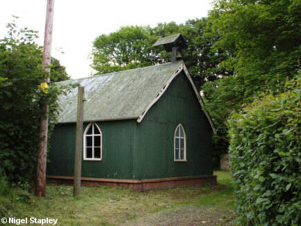
All Saints is a curious building, looking like little more than a large shed with a bell on it. It is part of the Parish and Benefice of Llanfynydd, and appears to be without an incumbent clergyman at present. Further than that, I've been able to discover little.
I ate my lunch in the little grassed area in front of the porch, before setting off back up to the Post Office, and turning left onto the main road again.
Heading down to Ffrith (The Ffrith to us; we're as bad as the French for putting definite articles in things), I wanted to take the track leading down to the old pack bridge, but I wasn't sure where the track started, or whether the bridge was open (I'd heard that it had been closed quite recently for repairs).
I found the track, as it was signposted as a bridleway, but became temporarily flummoxed by the mechanism for opening the gate to it. I then remembered that I'd seen gates like this before, and all that was needed was to move the vertical handle which was sticking out of the top. I yomped on down the track, shortly reaching a stretch which descended into the gloom of the woods and which was, as a consequence, slightly soggy underfoot.
I finally emerged into a paved area, and found myself down by the river. To the north of the ford stands the pack bridge...
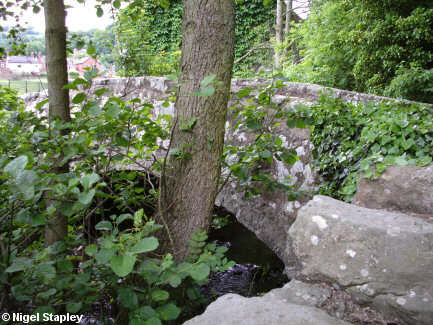
...and this I crossed onto the old Cymau Road. I wandered around the recreation ground for a while trying to find the plaque that Time Team had left there, but couldn't see it, and so I made my way out onto the main road through the Ffrith.
Ffrith used to have something in common with Ffrwd (apart from the definite article), in that the old Denbighshire/Flintshire boundary used to divide the village up, as it ran along Nant Y Ffrith and under the bridge which forms a very effective traffic bottleneck at the southern end of the village. However, a more recent re-alignment turned the border to the south east, and now only a few residences by Ffrith Hall fall in to what is now Wrexham County Borough.
Having marvelled at how difficult it must be to drive through the village given that the constriction caused by the bridge is further exacerbated by all the cars parked down the northbound side, I made my way up to by the Bluebell pub and turned left onto Valley Road. A short way up, I found myself in the shadow of this:
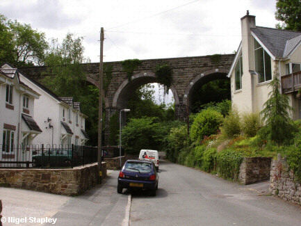
This is one of two viaducts which carried this stretch of the former Brymbo-Mold railway line. The other, a few hundred yards to the south-east behind Ffrith Hall, was taken down some years ago, leaving only the pillars standing. The line, which carried passenger traffic from 1898 until 1950, ran on an embankment above the village. Off to the right of this picture, the former station-master's house still stands. You can read more about Ffrith station and the line in general here.
Going under the viaduct led to the junction of two more bridleways. The one on the right goes up Nant Y Ffrith (the stream itself flows under the left-hand side of the bridge in this picture and behind the houses on that side), whilst the left-hand path goes up to Glascoed (The Glascoed to us - I did tell you, didn't I?). It was this path I took, not knowing - as I had never walked it before - in what condition it might be (I'd heard reports that it wasn't too good in places).
To be fair, the path is in pretty good nick except for the odd area which is a bit wet through not getting much in the way of sunlight. I slogged slowly up the slope until I came to this:
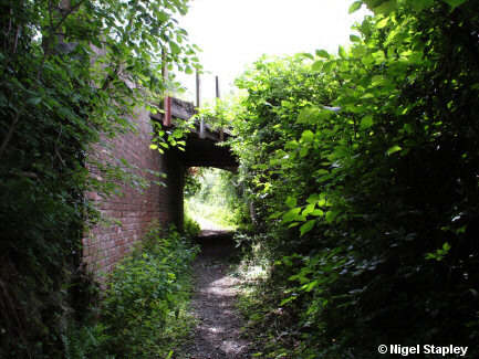
I couldn't figure out why there should be a bridge here when there wasn't - to the best of my knowledge - a road anywhere nearby, but it seems that there is a trackway here, possibly related to forestry work further up (I discovered later that it was a tramway to the quarries further up). Whatever its purpose, I took a short break here, before resuming my progress (the word is appropriate only in its strictest sense here) up the track. Said progress was hampered by the fact that it started getting steeper as it neared Glascoed Hall. I looked across to the east at this point and saw how far the houses on Mount Zion seemed from there, knowing that they marked the last couple of hundred yards of the journey.
Eventually, I emerged sweating onto Glascoed Road and freewheeled down to Glascoed wood itself, pausing only to try to make conversation with a couple of horses in an adjoining field, one of which seemed to have hiccups, or possibly hay fever.
Having followed the road through the woods, I was then faced with the long, steep road out the other side back onto Minera Road. When you're standing at the bottom of that hill, it seems absolutely infinite, and the only way you can do it is to put your head down, not raise thine eyes to the hills and hope that you'll remember to stop before you walk out into the middle of the main road. This I managed, clambered up the footpath directly opposite onto Pool Road and then coasted down home again.
Using my standard measurement method of a straight-edge of paper with marks on, I seem to have done just about six miles in a touch over five and a half hours. Not bad, all told.
More pictures from my latest peregrinations will probably appear in The Gallery (see left sidebar for the link) soon.


 This Is Not A
BLOG!


